Being a mountain cyclist in Suffolk is a bit of an oxymoron. So I’ve bitten the bullet and got some road tyres. I have no intention of giving up off-road cycling but it’s just more practical to do the majority of my cycling on the road. What’s more the local forests such as Tunstall and Rendlesham are criss-crossed by well made up trails that don’t really require off-road tyres, so I don’t need to spend too much time on the boring black stuff.
As a side-effect of this I’ve been looking at some online tools to help with route planning and the like. The best straight-up map I’ve found so far is provided by Sustrans, the Sustainable Transport charity.
The only problem I’ve found is the lack on information on the state of some of the off-road, and to some extent on-road sections. Some of them would be unsuitable for delicate road bikes and would require a hybrid if not a dedicated cross-country (XC) bike. The vast majority of routes are no cause for concern, however.
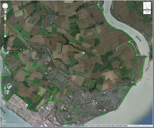
Google also have cycling maps, the cycle tracks highlighted in green…
These include many of the Sustrans routes as well as other cycling facilities. The problem I’ve found is that they’re not entirely accurate. The above example (as of the time of writing) includes a large section alongside the River Deben. Some of it is made-up track, but the surface is very poor and narrow. The rest is just a mud track. I’ve bumped into similar problems elsewhere too – overall I’d recommend not trusting the Google Cycling Layer unless you’re an experienced off-road cyclist.
On my smartphone I have a few apps, but one of the most useful is OS Atlas. It’s pretty basic, its main advantage is that it displays the Ordinance Survey’s 1:25k scale mapping. This is extremely useful for navigating because it contains a good level of detail not just about the roads but about landmarks. It also has GPS integration so it can show you as a dot on the map. The app’s not free but it is cheap. There is a free version but this doesn’t work terribly well. Beware that it does rely on an internet connection.
For full browsers the Ordinance Survey themselves offer the 1:25k scale mapping via their Getamap interface – you need to make sure that you have “Leisure” maps selected.
There are a number of online route planning and measurement systems. For a quick calculation of distance Map-O-Meter is good. The system I use for planning and recording rides however is MapMyRide. There’s a smartphone app to record your rides and upload them to the web site for proper analysis. It has a route and course feature so it will detect when you’re repeating and ride and you can compare performance. It also allows you to jump onto other people’s published courses so you can compare your performance with everyone else who’s ridden that route. You can also search for other people’s routes and courses in any given area, although they do tend to be “my commute to work” rather than “a scenic 30 mile loop around Lavenham”.
There’s one final web site that I’d like to mention – whilst over the past few weeks I haven’t needed it much the rain radar at Rain Today is about the most useful weather forecast I’ve found. It doesn’t actually do a forecast (unless you pay), what it shows you is where the rain is now and where it’s been recently. This is about as good as it gets for being able to predict if you’re going to get soaked on your 2 hour ride.